 Appendix A
 |
Table of Contents | Appendix C
|
| Natural Borders Homepage |
Appendix B
Methods for the
Development of
Human Geographic Boundaries
and Their Uses
By
|
Appendix A |
Table of Contents | Appendix C
|
| Natural Borders Homepage |
Appendix B
Methods for the
Development of
Human Geographic Boundaries
and Their Uses
By
James A. Kent J.D.
The James Kent Associates
P.O. Box 3165
Aspen, Colorado 81612
970.927.4424
jkent@jkagroup.com
Kevin Preister, Ph.D.
Social Ecology Associates
P.O. Box 3493
Ashland, Oregon 97520
541.488.6978
kevpreis@jeffnet.org
June, 1999
In 1998, the
Bureau of Land Management (BLM) and James Kent Associates (JKA) signed a
cooperative Assistance Agreement for the purpose of furthering the emerging
paradigm within BLM of ecosystem management. As the term ecosystem management
has become interpreted broadly to include humans into the equation of public
land management, and as the collaborative partnership movement has broadened
and deepened throughout the country, additional resources for understanding and
incorporating community interests into decision-making have been sought.
Because of JKA's experience in the last thirty years related to these concerns,
its success in the field, and its well-developed methodology of community
assessment, mapping and management, JKA was asked to assist BLM in:
"refining and demonstrating community assessment methods to help the
BLM and its partners address social and cultural criteria for more effective
public participation and collaboration when making planning and other decisions
- a key element in building capacity for community-based approaches to land and
resource management."
JKA's
methods for performing community assessments through The Discovery Process (tm)
workshops, mapping human geographic units, and related management training can
help local governments, federal agencies, and community organizations better
understand and address social and cultural criteria. Also, JKA's methods add value to the human dimension of
bio-social ecosystem management, strengthening social justice considerations
while complementing more traditional, economics-based approaches. The BLM and
JKA share a common commitment to helping communities and federal land
management agencies work together in a more productive way.
This
paper focuses on the mapping component of a larger process termed the Human
Geographic Issue Management System (HGIMS). The system is designed to create
productive harmony between land and people through cultural alignment between
informal community systems and the formal institutions that serve them. The
system has two phases:
1.
The Discovery Process (tm) is the description of communities "from the inside out,"
that is, from the perspectives of people who live in those communities. By
focusing on Cultural Descriptors (publics, informal networks, settlement
patterns, work routines, support services, recreation routines and geographic
features, defined more fully below), a fairly complete picture emerges of
community life, communication patterns, important citizen issues, and social
and economic trends affecting an area. One product of the Discovery Process is
a human geographic map that shows, from a social and cultural perspective, where
one area ends and another begins.
2.
Issue Management (tm) is the process of identifying emerging issues in the
community and including them in the management process of planning and
implementing projects designed to maintain sustainability of people and the land.
It is a method of minimizing surprise and disruption by creating a predictable,
natural process of communication and action so that the well-being of both
community and the landscape is addressed.
The
balance of this paper will focus on the rationale for the creation of human
geographic maps. It will outline the methodology used for their development,
especially the seven cultural descriptors. It will close with our vision of how
a GIS-based HGIMS offers a powerful tool for responsive management in regional,
multi-jurisdictional, multi-species ecosystem projects.
Human
geographic maps were developed to provide a context for implementation of the
National Environmental Policy Act (NEPA). It was discovered early that town boundaries, county boundaries and
regional planning boundaries did not provide the context needed for
understanding and implementing the social/cultural aspects of NEPA.
NEPA is well known as the first piece
of national legislation to declare a national policy on the environment. It has
attracted most attention for Section 102 that calls for the completion of
Environmental Impact Statements (EIS) for all "major federal actions." Most of
the political conflict and court cases have invoked the procedural adequacy of
the EIS. A report from the Council on Environmental Quality summarized
twenty-five years of experience with NEPA by saying procedural adherence to
Section 102 has led to a dynamic of "issue stacking" in which identified
concerns become included in the EIS process for analysis, accumulating
controversy as project review moves forward. The report, along with many NEPA
professionals, have recently begun to advocate for using the NEPA process not
only to identify issues early but to resolve them as the project is reviewed
(CEQ 1996).
Section 101 of NEPA, by contrast, has
been under-emphasized. It contains the clearest policy intent of the law. It
first acknowledges people's impact on the land through population growth,
high-density urbanization, industrial expansion, resource exploitation, and
technological advances. It then declares that it is the continuing policy of
the federal government, in cooperation with State and local governments, and
other concerned public and private organizations to
"...create and maintain conditions under which
man and nature can exist in productive
harmony, and fulfill the social, economic, and other requirements of
present and future generations of Americans" (emphasis added).
The
Bio-social Ecosystem Management Model (Figure 1) is a way to conceptualize the
productive harmony described in NEPA. Based on the long-standing observation
that the well-being of people and the land are inextricably tied together, the
figure makes the case that permanence and diversity are valued characteristics
for both physical and social environments (Preister and Kent 1997).
Sustainability is created when land use decisions are shaped around the
question, "How can we enhance the permanence and diversity of this physical
ecosystem in ways that promote the permanence and diversity of the human
communities?"
It is our view that the same level of
effort used to understand physical ecosystems must be applied to understanding
social ecosystems and to integrating the two in a holistic management system.
Moreover, in understanding
Figure One
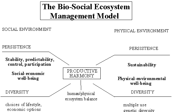
(Source: Preister and Kent 1997)
social ecosystems, it is not enough to
understand the formal level of communities, i.e. the macro-level data, the
county commissions, and state government. Rather, it is important that research
methods reflect the social reality of everyday people--their routines,
traditions, beliefs and issues. We call
this the informal level of community. The Discovery Process (tm), the major
Our experience has shown that most
proposed projects that run into trouble, fall behind schedule, and generate
community opposition may technically comply with the legal and regulatory
requirements of their various local, state, and federal regulations. However, they often fail to discover the
real issues existing in the community that are held by people who don't come to
public meetings and are therefore excluded from the project design and review.
One of the major
Human
geographic mapping allows a resource manager to know where the culture borders
are in relation to management decisions. For instance, the Roaring Fork Valley
between Independence Pass and the confluence of the Roaring Fork and Colorado
Rivers (Aspen and Glenwood Springs) has three county governments and four town
governments with various jurisdictions associated with each government. If the resource manager recognizes the
Roaring Fork Valley as one social/cultural unit and manages within the informal
networks, the chances for program and project success increase dramatically.
The resource manager can then easily distinguish the difference between
place-based communities and regional or national publics of interest and
interact with them in a specific, appropriate manner.
In
the case of Environmental Justice Guidelines (EJG), necessitated by Executive
Order 12898 to which federal agencies must comply, human geographic mapping
provides the cultural boundaries so that the resource manager knows where the
resource management decision, or impact, ends culturally. Until human geographic mapping was created,
managers had no idea how far they had to reach to include the people affected
by EJG. Seldom, if ever, would it
include a complete county. However, it
could include two towns depending on the human geographic boundaries involved.
The
form of management required is clearly one of "participatory communication," in
which the proponent of the action engages the community within its cultural
boundary system in a manner consistent with its own cultural beliefs,
traditions, stories and approaches to the environment, including cultural
stewardship.
Human-geographic boundaries represent
the informal systems of communities. They reflect the boundaries within which
people conduct their lives. Day to day interactions, talks with neighbors and
co-workers, shopping, visiting and family ties operate within predictable
geographic patterns.
In our experience, human-geographic
maps represent a resource to land use managers and others involved in
experiments in ecosystem management and restoration. Based as they are on how
people actually live their lives, and how people mobilize their social and
physical resources to meet life's challenges, the maps provide an inside view
of the local terrain of a place-based culture.
Specifically, the advantages of
human-geographic mapping for bio-social ecosystem management are these:
Natural resource managers now have the capability to staff
the land base, with its attendant social and physical capital, as an integral
unit, rather than staffing programs structured with artificial administrative
boundaries. This capability of "staffing the culture" is a key strategy when
coordinating or integrating federal land management administration.
The maps reveal natural lines of mobilization and inclusion
of local residents, revealing limits of social ties;
Maps allow sensitivity in siting facilities and programs
that reflect how people actually identify with and use the land;
The mapping further promotes a bio-social model of
productive harmony, providing a rationale for including issues of community
health and well-being into considerations of natural resources management;
For
the first time, a tool is available for decision-makers committed to aligning
community culture with project outcomes. For the increasing number of practitioners who believe community and
ecological health to be inextricably tied, the maps provide a physically
defined, cultural-based arena within which decisions are made and resources are
allocated to enhance permanence and diversity in the bio-social ecosystem.
The Discovery
Process yields five scales of human geographic boundaries:
1. Neighborhood
Resource Units (NRU)
2. Human Resource
Units (HRU);
3. Social
Resource Units (SRU);
4. Cultural
Resource Units (CRU); and
5. Global
Resource Units (GRU).
The
figures below show two of these five scales, the Human Resource Unit (HRU) and
the Social Resource Unit (SRU). HRUs are the smaller units and are shown in
blue, while SRUs are larger units and are shown in red. It is best to visualize
blue lines under the red lines, so that SRUs are rightly seen as the
aggregations of the HRUs within them.
Human
Resource Units are roughly equivalent in size to a county but seldom correspond
to county boundaries. HRU boundaries are derived from the seven cultural
descriptors defined below and by self-reporting by residents living in these
areas.
HRUs
are characterized by frequent and customary interaction. They reveal
face-to-face human society where people could be expected to have personal
knowledge of each other and informal caretaking systems are the strongest.
People's
daily activities occur primarily within their HRU including work, school,
shopping, social activities and recreation. Health, education, welfare and other public service activities are
highly organized at this level with a town or community almost always as its
focal point.
A
sense of place; a sense of identity with the land and the people, a sense of a
common understanding of how the resources of their Unit should be managed, and
a common understanding of how things are normally done characterize this
territorial level.
The
regularity of interaction within an HRU reinforces a recognition and
identification by the residents of natural and man-made features as
"home." Because of this
familiarity, boundaries between Human Resource Units are clearly defined in the
minds of those living within them. Human Resource Units aggregate to form Social Resource Units in the JKA
mapping system (Figure Two) (Quinkert et.al. 1986).
Social
Resource Units are the aggregation of HRUs on the basis of geographic features
of the landscape, often a river basin, for example, and on the basis of shared
history, lifestyle, livelihood, and outlook. At this level, face-to-face
knowledge is much reduced. Rather, social ties are created by action around
issues that transcend the smaller HRUs and by invoking common values ("We are
ranching country around here.").
SRUs are best
characterized by a sense of belonging. These are rather large areas and one's intensity of perception as to the
Unit's boundary is much more general than at the Human Resource Unit
level. Those hold a general feeling of
"oneness" who are a part of this regional Unit, and a general understanding and
agreement on values and the attributes of being a part of the Unit.
The physical
and biological environments play a large role in the development of the
cultural pattern at this level of the progression. To a large degree, these environments determine the kinds of
basic industries available for people to develop their culture around, and how
the industries function in the most effective manner to preserve and strengthen
the cultural pattern of the Unit.
Population
density is also a factor that defines and delineates Social Resource
Units. Large areas of high population
density separate Social Resource Units from surrounding areas of lesser
population, but they still reflect in their cultural pattern the broad physical
and biological environment within which they occur.
Figure Two
Human Resource Units in the
Four Corners SRU of Utah, Colorado, New Mexico and Arizona
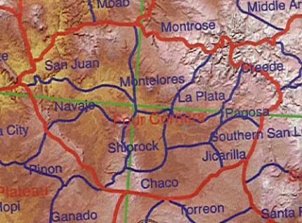 |
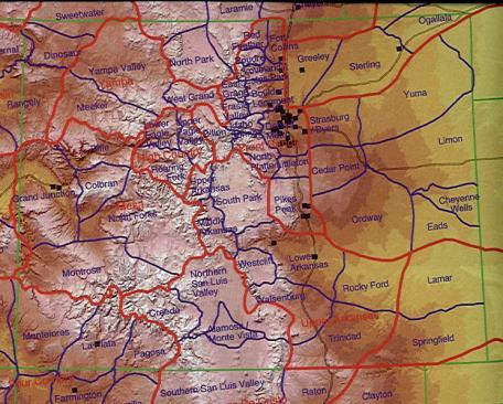
Social Resource Units of Colorado
Social
Resource Units (Figure Three) are usually larger than single cities (the Front
Range SRU, for example, is larger than the metropolitan area of Denver), but
are smaller than most states. However,
a Social Resource Unit will sometimes include portions of several states as is
the case with the Four Corners SRU which includes portions of Colorado, New
Mexico, Arizona and Utah. The
megalopolis of New York City, which includes portions of New Jersey and
Massachusetts, is another example of how Social Resource Units are not confined
by administrative or legal boundaries. Social Resource Units aggregate to Cultural Resource Units in the JKA
mapping system.
Seven
Cultural Descriptors Used in The Discovery Process and to Determine Human
Resource Unit (HRU) Boundaries
ONE: Describe the publics and their
interests
A public is any
segment of the population that can be grouped together because of some
recognized demographic feature or common set of interests. A public may exist currently or at some
future date; it may reside permanently in a geographic area, or may live
elsewhere and have an interest in the management of natural resources. Sample publics include ranchers, loggers,
tourists, small businesses, industries, miners, senior citizens, minorities,
homemakers, youth, preservationists and governmental bodies.
By
identifying publics and characterizing each public's interests, a resource
manager can understand how segments of a population will be affected
differently by resource decision making. Also, predictions can be made about how changing public interests will
influence management in the future.
What publics are within the immediate sphere of influence of
resource management and decision making activities? What are the ongoing interests of each identified public? Which of the publics have specific
resource-related interests? Are there
any public interests or activities that affect resource management activities?
Is there any public that is directly affected by the
resource decision making process? Which
publics currently benefit from jobs generated by the resource outputs? Are there any individuals, businesses or
industries that are dependent upon a specific output?
Which publics could potentially benefit from resource use
and development activities? Which
publics could potentially be affected from a change in current management
activities?
What publics are outside the immediate sphere of influence
of resource management activities, but use the resource or are involved in the
decisionmaking process? Do these
publics have a relationship to the resource because they affect or are affected
by resource management activities?
TWO: Describe the networks
A network is comprised of individuals
who support each other in predictable ways and have a shared commitment to some
common purpose (Figure Four). Networks
may be informal arrangements of people tied together for cultural, survival, or
caretaking reasons. Networks may also
be formal arrangements of people who belong to an organization, club or
association, which has a specific charter or organizational goals. Networks may function in a local geographic
area or may influence resource management activities from regional or national
levels. Examples of informal networks
include ranchers who assist each other in times of need, miners who work on the
same shift, grass-roots environmentalists, or families who recreate
together. Examples of formal
organizations include a cattlemen's association, coal mining union,
preservationist or snowmobile club.
A knowledge of networks citizens form
to express their interests is essential for identifying public issues relating
to management activities and for monitoring the effectiveness of resource
decisionmaking.
What informal networks do each of the identified publics
form to express their interests? What
is the function of each network? When
and where does each informal network gather to share information or services? How do the members of each network
communicate with each other?
Which networks function in an ongoing manner for cultural,
caretaking or survival reasons? Which
networks are temporarily involved around particular events or issues?
What is the informal leadership in each network or who is
respected and why? Are any networks
more effective than others in addressing the issues that concern them?
Which networks extend beyond the local level and function on
a regional or national scale? Are there
any regional or national networks that influence resource management
activities?
What formal organizations, associations or clubs do the
identified publics form to express their interests? What is the purpose of each group? When and where does each formal organization meet to share information
or provide services? How do the members
of each group communicate with each other? Which organizations operate in an ongoing manner and which operate
temporarily?
What is the formal and informal leadership in each
organization or who is respected and why? Are any groups more effective than others in addressing the issues that
concern them?
Which organizations have a membership that extends beyond
the local level and operates on a regional or national level? Are there any regional or national
organizations that influence resource management activities?
Networks are contacted through program
and action development to:
Monitor changing public attitudes and activities
Identify and evaluate public issues
Dispel rumors about management activities
Inform public of current and future plans
Discuss opportunities available to address issues
Prepare for formal public participation and news releases
THREE: Describe the settlement pattern
A settlement pattern is any
distinguishable distribution of a population in a geographic area, including
the historical cycles of settlement in an area. This cultural descriptor identifies where a population is located
and the type of settlement categorized by its centralized/dispersed,
permanent/temporary, and year-round/seasonal characteristics. It also describes the major historical
growth/non-growth cycles and the reasons for each successive wave of
settlement.
Knowledge of settlement patterns
provides a resource manager with a basis for predicting the significance of
probable population changes associated with resource management and development
activities.
Where do people live and how is the population distributed
in the immediate geographic area? Are
the settlement areas dispersed throughout the countryside and/or centralized in
towns and cities?
What is the history of settlement? What types of people came with each successive wave of
settlement? Why did people settle in
the area? Are there any particular
characteristics of the settlement pattern that make it unique?
Have there been any significant increases or decreases in
population in the past? What caused
these? Is the current settlement stable
or on the increase or decrease? What is
causing this trend?
What major changes have occurred during past settlement
cycles? How rapidly have these changes
occurred? How have people handled or
accepted change in the past? Are these
changes easily recalled by people?
What new publics have settled in the area in recent
years? How have long-term residents
accepted newcomers? Is the area settled
with diverse or homogenous publics? Which settlement areas are integrated with diverse publics and which are
not and why?
What future publics can you anticipate residing in the
immediate geographic area? What will be
the possible causes of the future settlement patterns? How rapidly will the settlement occur?
FOUR: Describe the work routines
A work routine is a predictable way in
which people earn a living, including where and how. The types of employment, the skills needed, the wage levels and
the natural resources required in the process are used to generate a profile of
an area's work routines. The
opportunities for advancement, the business ownership patterns, and the
stability of employment activities are also elements of the work routine
descriptor.
A knowledge of work routines can be
used to evaluate how alternative uses of natural resources will affect the ways
people earn a living and how changes in work routines, in turn, will impact
future natural resource uses.
What are the ways in which the people in the immediate
geographic area earn a living? Are
people self-employed or employed by small business or large corporations? What are the primary employment activities
and the approximate percentage of people involved in each sector?
What kinds of skills are required of people in the various
types of employment? What level of pay
is received? Has there been any significant
shift in employment activities or income levels in recent years? If so, has the shift influenced resource use
or management activities?
Are the majority of businesses owned locally or by
corporations and people from outside the area? Are generational cycles of families in the same employment typical?
Are there any work routines that are seasonal in
nature? Are the seasonal jobs taken by
residents of the area or from outside the area? Do many people work two jobs or is it common for families to have
two wage earners? Is the unemployment
significant? If so, among which
publics?
What is the average age of the labor force? Are youth able to find employment in the
area? Are there adequate opportunities
for advancement? Do people change jobs
frequently or work in the same activities most of their lives? Which publics have a strong cultural
identity associated with their work?
Is there a compatible mix of employment activities? Which activities are aggravating each
other? How do current resource
management practices maintain the mix of activities? How could future changes in resource management stabilize or enhance the current employment mix?
FIVE: Describe the supporting
services
A supporting service is any arrangement
people use for taking care of each other. Support services occur in an area in both formal and informal ways. Examples of formal support services include
the areas of health, education, law enforcement, fire protection,
transportation, environment and energy. Examples of informal support activities include the ways people manage
on a day-to-day basis using family, neighborhood, friendship or any other
support system.
A resource manager can use the
supporting services descriptor to evaluate how alternative uses of resources
will affect the ways people take care of each other and how changes in
supporting services, in turn, will impact future natural resource management.
Where are the formal support services such as the
commercial, health, education, transportation, protective, energy facilities
located? What is the geographic area
that is serviced? Which services are
used routinely by people in the area? Which services do people have to leave the area to obtain?
How are the services operated? Are the facilities and services provided adequate for the
area? Which are inadequate and for what
reasons?
What informal supporting activities occur in the area? How do people care for each other on a
day-to-day basis and in times of crisis? Do families, friends, church or volunteer organizations provide support?
How much do people take care of each other on an informal
basis and how much do people rely on formal services? Do people still trade for services or almost always pay cash for
services?
How are the elderly, single parents, youth, poor and others
taken care of? Are informal systems
used such as neighborhoods, or are formal organizations used for
assistance? To what degree do people
take care of their own problems or rely on government agencies and formal
services? Do all people have access to
the supporting services and activities?
Has the amount or type of supporting services changed in
recent years? How has the provision of support
services and activities changed? What
has contributed to these changes?
SIX: Describe the recreational activities
A recreational activity is a
predictable way in which people spend their leisure time. Recreational opportunities available,
seasonality of activities, technologies involved, and money and time required
are aspects of the recreational descriptor. The frequency of local/non-local uses of recreational resources, the
preferences of local/non-local users, and the location of the activities are
also included.
A manager can use this cultural
descriptor to evaluate how alternative uses of resources will affect the ways
people recreate and how changes in recreational activity, in turn, will impact
future resource management.
What are the principal types of recreational activities of
people in the area? Which activities,
sites or facilities are most preferred? Are certain activities seasonal?
What is the orientation of the leisure time activities? Are the activities of individual, family,
team, church or school related? Are
there significant recreational activities in which a wide range of individuals
participate? How do groups like youth
and senior citizens recreate?
How much time is spent in recreational activities? How much money is spent on recreational
activities? What kinds of recreational
vehicles or equipment are used? Do the
majority of activities occur on public or private lands and facilities?
Are there recreational opportunities in the area that
attract people on a regional or national scale? What activities, sites or facilities are most preferred? Are certain activities seasonal? Is there a significant number of businesses
that rely on the income from these recreational activities? Which activities relate to natural resource
uses and management?
Have there been any major changes in recreational activities
in recent years? What events caused the
change? What types of sporting goods or
recreational license sales have been on the increase? What recreational sites or facilities have experienced an
increase of decrease in use and why? Do
current recreational sites and facilities accommodate the demands? What changes in recreational activities are
anticipated in the future and why?
What written and unwritten rules do people use when
recreating? Is there much of a
difference between the recreational activities of residents in the area and
those who temporarily visit the area? How does the type of recreation differ?
SEVEN: Describe the geographic
boundaries
A geographic boundary is any unique
physical feature with which people of an area identify. Physical features separate the activities of
a population from those in other geographic areas such as a valley that people
identify as being "theirs" or a river that divides two towns. Examples of geographic boundaries include
topographic and climatic features, distances, or any unique characteristic that
distinguishes one area from another. Geographic boundaries may be relatively permanent or short-lived; over
time, boundaries may dissolve as new settlement patterns develop and as work
routines and physical access to an area change.
By knowing the geographic boundaries of
a population, a manager can identify and manage the effects of natural resource
use and development that are unique to a particular geographic area.
How do people relate to their surrounding environment? What geographic area do people consider to
be a part of their home turf? Within
what general boundaries do most of the daily activities of the area occur? How far do the networks people use in their
routine activities extend throughout the area?
What is the area people identify with as being
"theirs?" Are there any particular
characteristics, social or physical that people think are unique to the
area? What features attracted people to
the area or provide a reason to stay?
Are there any physical barriers that separate the activities
of a population from those in other geographic areas? Are there any evident social barriers?
What are the predominant uses of the land and what
topographic or climatic features support such activities? What percentage of the geographic area is in
the private and public sector? Is most
of the private land owned by year-round residents or by people from outside the
area?
Have
there been any significant changes in the use of the land and its resources in
recent years? What has caused the
changes? How have these short- or
long-term changes affected people and their ways of life? How accessible is the area to external
influences? What kind of
influences? Are these beneficial or
negative impacts on the area?
Human
Geographic Issue Management is the process of creating productive harmony at
the project level by assisting change agents in integrating resource
decision-making with considerations of community health. Issue management is
the ability of an organization to identify and respond to public issues in a
timely and appropriate fashion in order to culturally align land management
agencies with the informal community systems which they serve. It is a way to
achieve bio-social ecosystem management because it allows a balance to be
created between biophysical and human habitats.
The theory of
issue management is that issues, or citizen statements which can be acted upon,
present the greatest range for responsive options if issues are identified in
the emerging stage of development. Issues that are allowed to become
disruptive, by definition, are resolved at higher levels of formal society. To
identify emerging issues, it is necessary to have direct contact at the
informal level of community. It is at this level where people are just
beginning to become concerned about real or perceived changes in their
environment and to mobilize their networks for action. Issues that are resolved
at the emerging stage increase community resilience that in turn provides local
support for agency projects. Moreover, issues resolved at this stage cannot be
appropriated at regional and national levels for political purposes. Figure
Four displays the issue management process.
The issue
management process provides social, cultural and economic information through
face-to-face interaction that is essential for day-to-day operations, baseline
community studies, environmental documents, as well as for planning and
analysis. It is a means to develop relationships that foster community
partnering and collaborative issue resolution. The JKA Group has been
successful in applying these concepts at all levels and scales of agency and
community operations.
Figure Four
Issue Management at
the Project Level
(Source:
Preister and Kent 1997)
Practitioners
of Issue Management:
1. Describe
communities in social, economic, and cultural terms.
2. Identify and
map informal networks and major communication pathways.
3. Identify the
issues related to the community and to land management in a systematic way and
incorporate them into agency decision-making.
4. Institute
"issue-tracking" mechanisms within the agency in order to enhance
responsiveness and stable decision-making.
Geographic
Information Systems (GIS) provide the technical capability of applying this
kind of responsiveness to regional, multi-disciplinary and multi-jurisdictional
efforts currently underway, such as:
The Mojave Desert Ecosystem Program,
Watershed coordination efforts in the Central Valley of
California,
The Southwest Strategy in Arizona and New Mexico to
coordinate collaborative ecosystem recovery.
These
and other efforts are characterized by increasing sophistication in the
collection and display of biological data and in the monitoring of such data
for planning and management purposes. However, the sophistication on the social
and cultural side has been very low. At best, census data and other social and
economic information are displayed with no context of process within which to
use and provide value to the information. Nowhere are displayed citizen issues,
trends affecting local communities, key communication pathways, or the beliefs,
traditions, values, aspirations and visions of local communities.
The
danger of this limitation is that ecosystem decisions are driven too much by
biological and physical science, technical considerations and agency interests.
Science, of course, is valued and necessary but when its application is not
tempered by the context of human considerations, the "tyranny of the expert"
syndrome can dominate, with disastrous biological, political, cultural and
economic costs.
The
concept of Social Resource Unit (SRU) was first used in relation to work with
the U.S. Forest Service Region 2 and is described in Kent and Greiwe (1978).
Our regional efforts stem from work we did with the City and County of Honolulu
in the late 1970s in which we geographically mapped the island of O'ahu into
human resource units. The island of O'ahu had a population of about 800,000.
Community fieldwork identified informal networks, emerging issues, key
caretakers, communicators, and opportunities, for use by the city in dealing
with intense development pressures (Kent and Ryan 1980, 1981). This work
pre-dates GIS capability.
In
1991, we assisted Washoe County, Nevada with the implementation of their Issue
Management program in which county staff performed similar human geographic
mapping. The result was a map showing neighborhood boundaries identified by
residents and a system for monitoring emerging, existing and disruptive issues.
Their system has the ability to call up issues either by geographic location or
by type of issue. The system also allows for the tracking of issues and their
resolution over time. Staff print "Issue Alerts" for their county commissioners
so that action can be taken in a timely manner and costly disruptive issues
prevented from occurring (Kent 1993). The Washoe County system has not yet
integrated the data files of description and issues with the GIS mapping.
Our
vision for a GIS-based Human Geographic Issue Management System presumes that
baseline social, economic and cultural data have been gathered, and human
geographic boundaries displayed through maps are generated. Data sets capable
of being displayed spatially that we feel are important in promoting a
bio-social ecosystem approach include:
Cultural description (settlement patterns, publics,
networks, work routines, support services, recreation activities, geographic
features);
The range of public issues related to community life and to
resource management;
Social and economic trends reported by residents (often
pre-dating statisticians by as much as five years) that present pro-active
opportunities;
Communication pathways (gathering places, informal networks,
the who, where, and when of communicating);
Identification of essential and effective civic protocols
citizens use to manage their relationships with each other and the land;
Opportunities identified by citizens for resolving current
community and resource management challenges.
When this information is paired and
layered with biological and physical data, a powerful tool has been created for
anticipating the effects of decisions and for fostering collaboration in
considering possible courses of action.
Issue
management focuses clearly on the use of federal lands to address the social
benefits, issues and impacts created by use of the federal resource. Hence,
poverty, underemployment, growth rates, sector changes (agricultural,
industrial, services), affordable housing, transportation, recreation, and
urbanization are related to community health. These factors are the concerns of
federal land use management agencies to the extent that they impact public
lands and to the extent that federal decisions, within the bounds of
sustainable ecosystems, can contribute to addressing them. Indeed, we are
entering an era where urban policy in the western United States is imperative
for land use agencies if resource quality and availability is to be assured in
the future.
Earlier
in this paper we have made the case that NEPA's Section 101 permits and
encourages, through its productive harmony clause, the scrutiny of and response
to social and cultural considerations. It is the authors' experience that ample
legal justification exists in Section 101 for agencies to consider "off site"
impacts, including those listed above. At M~kua Beach, Hawaii, working through
the Department of Defense, off-site considerations permitted by NEPA and
Environmental Justice guidelines sustained the military use of the beach for
training purposes and accomplished several social objectives as well (James
Kent Associates and Institute for Sustainable Development 1998a, 1998b).
A
broader perspective, such as we are suggesting, has resulted in successful
resolution of community concerns regarding federal actions and the creation of
productive harmony at the local level. For the first time, managers can determine how far "off-site" they have
to go with various issues - either to the line of the Human Resource Unit or to
the line of the Social Resource Unit. In addition, the maps provide a
geographic context for "staffing projects through the culture" rather than
imposing projects "on the culture."
Caldwell, Lynton K.
(1998) Beyond
NEPA: Future Significance of the National Environmental Policy Act. The
Harvard Environmental Law Review 22(1): 203-239.
Council on
Environmental Quality
(1996) The
National Environmental Policy Act: A Study of Its Effectiveness After
Twenty-five Years. CEQ, Executive Office of the President, November.
James Kent
Associates
(1993) Issue Management Handbook, Washoe County
Issue Management System, Washoe County Department of Comprehensive Planning,
Reno, Nevada; June.
James Kent Associates & Institute
for Sustainable Development
(1998a) APPENDIX
G: Decision Support Document: Community Resources Summary and Recommendations,
Marine Corps Amphibious Training at M~kua Beach. Prepared for Commanding
General, Marine Corps Base Hawaii, Environmental
Assessment for Marine Corps Amphibious Training in Hawaii, June.
James Kent Associates & Institute
for Sustainable Development
(1998b) Guidelines
for Community Interaction: Developed as Part of an Expanded Culture Assessment,
Environmental Assessment Project for the Marine Corps Amphibious Training in
Hawaii, July.
Kent James A. & John Ryan
(1980) Documentation
of the Methodology Used in Developing Guidelines for a Social Impact Management
System for City and County of Honolulu. Honolulu, HI: Honolulu Department of
General Planning, March.
(1981) A
Social Impact Management System for Honolulu: Final Phase Two Report. Honolulu,
HI: FUND Pacific Associates, July.
Kent, James A.
& Richard J. Greiwe
(1978) The Social Resource Unit: How Everyone Can
Benefit from Physical Resource Development. Mining Year Book, National Western
Mining Conference and Exhibition, The Colorado Mining Association.
Preister,
Kevin and James A. Kent
(1997) Social
Ecology: A New Pathway to Watershed Restoration. IN Watershed Restoration:
Principles and Practices, by Jack E. Williams, Christopher A. Wood and
Michael P. Dombeck (eds.), Bethesda, MD.: American Fisheries Society.
Quinkert,
Anthony K., James A. Kent & Donald C. Taylor
(1986) The
Technical Basis for Delineation of Human Geographic Units. Denver, Colorado:
SRM Corporation for U.S. Department of Agriculture, April.
|
Appendix A |
Table of Contents | Appendix C
|
| Natural Borders Homepage |